


Le meux

pascha
User
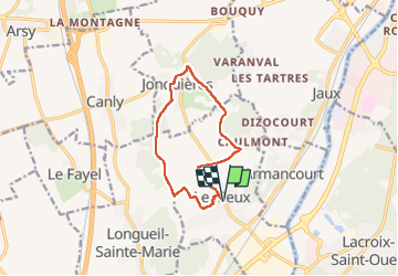

Length
10.1 km

Max alt
116 m

Uphill gradient
117 m
Km-Effort
11.7 km

Min alt
49 m

Downhill gradient
117 m
Boucle
Yes
Creation date :
2022-12-28 13:00:39.0
Updated on :
2022-12-28 15:25:38.919
2h24
Difficulty : Easy

FREE GPS app for hiking
 SityTrail
IGN / Geographical institutes
SityTrail Plus
The world is yours!
About
Trail Walking of 10.1 km to be discovered at Hauts-de-France, Oise, Le Meux. This trail is proposed by pascha.
Positioning
Country:
France
Region :
Hauts-de-France
Department/Province :
Oise
Municipality :
Le Meux
Location:
Unknown
Start:(Dec)
Start:(UTM)
481438 ; 5468185 (31U) N.
Comments